Introduction Study area Method: Photogrammetry Method: Water depth estimation Final riverbed surface Conclusions References Links & Acknowledgements

|
Introduction Study area Method: Photogrammetry Method: Water depth estimation Final riverbed surface Conclusions References Links & Acknowledgements |
|
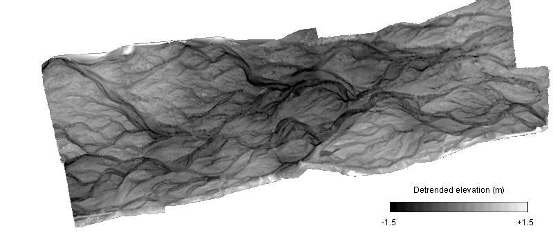
5: Final riverbed surfaces
In order to convert the estimated water depths to submerged bed elevation values, the water surface elevation must be modelled. This was achieved by using the post-processed dry-bed elevation map obtained using automated photogrammetry, blanking out the wetted channels using the classified image (Figure 5), and then interpolating an assumed water surface between adjacent banks. Estimated water depths (Figure 6) were then subtracted to give a wet-bed elevation map.
Finally, the wet-bed elevations were combined with the dry-bed elevation map to give a DEM surface of the whole study reach. To date, a final DEM surface has been calculated only for February 1999 (Figure 7).
Figure 7 Final 'total coverage' DEM for the study reach for February 1999. The topography has been detrended in the downstream direction to emphasise the local morphology.
5.1. Surface quality assessment
As with any new technology, it is important to test the quality of the riverbed surface produced using digital photogrammetric survey. The February 1999 surface was tested by using approximately 20,000 independant point elevations, surveyed by the NIWA and EC field teams using a combination of Total Station and Trimble RTK GPS. An automatic spatial-correspondence algorithm was used to associate surveyed and DEM elevations, with a maximum search radius of 0.5 m (giving a search diameter of 1 m, equal to the DEM grid spacing). The ME and SDE of the final surface are given in Table 2.
Table 2: The quality assessment results for the February 1999 final riverbed surface.
| Riverbed area | Points matched | ME (cm) | SDE (cm) | R (%) |
| Dry | 3700 | +17 | 26 | 98.8 |
| Wet | 11232 | +36 | 30 | 99.0 |
The quality assessment results are interesting because they are a good example of how photogrammetry is being pushed to an extreme. Given the scale of elevation change along the entire study reach (a vertical difference of around 17 m from the upstream to downstream end), the precision of the surface in terms of R is excellent. However, SDE shows how the local precision is actually quite large relative to the local relief. The ME suggests that there is a systematic bias in the riverbed surface, which is around twice as large in wetted areas. A relatively large ME in wetted areas is not surprising, given that the colour-depth method used to estimate water depth has a known maximum predicable depth, above which estimates will be too low, meaning the final surface will be too high. The systematic error in dry areas is more of a surprise, though is only a cause for concern if the error is found to be spatially variable. If it is a true systematic bias, all elevations will be around 17 cm too high, and the errors can be easily eliminated.
Introduction Study area Method: Photogrammetry Method: Water depth estimation Final riverbed surface Conclusions References Links & Acknowledgements